
-
Start

-
woj.zach.-pomorskie
-
ciekawe miejsca
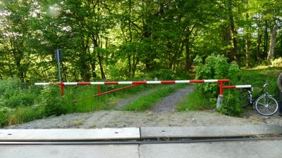
- Przystanek kolejowy w dzielnicy Podczele w Kołobrzegu
Przystanek kolejowy w dzielnicy Podczele w Kołobrzegu
Kołobrzeg jest uzdrowiskiem. Przed II wojną światową, kilka kilometrów od centrum, między morzem, a drogą w kierunku do Koszalina, zbudowano sanatorium dr. J.Reinke, gdzie leczono dzieci i młodzież z chorobami płuc (obecnie sanatorium Holtur). Po drugiej stronie drogi, w lesie, na potrzeby sanatorium zbudowano przystanek kolejowy, który działał prawdopodobnie do 1951 roku. Szlabany pewnie pamiętają te czasy, ale ciekawej konstrukcji na peronie już nie ma.

fot. 23 maj 2015, SNW
Współrzędne:
54°11'14.3"N 15°38'43.2"E
54.187294, 15.645333
54°11'14.3"N 15°38'43.2"E
54.187294, 15.645333
fot. 23 maj 2015, SNW
Poniżej zamieszczamy zdjęcia peronu z 12 kwietnia 2009 roku oraz zdjęcia z lasu i okolicy z lat 2006-2013.

fot. 1

fot. 2

fot. 3

fot. 4

fot. 5

fot. 6

fot. 7

tędy można rowerem wjechać do lasu,

ale drogi nie zawsze są przejezdne,

są strumienie przecinające drogi,

ładne mostki,

i drogi jak ta prowadząca do pomnikowych dębów.

Lasem można dojechać na lotnisko Bagicz i dalej w kierunku morza.

Po drugiej stronie drogi Kołobrzeg-Koszalin, gdy miniemy zabudowania sanatorium dojdziemy do grobli,


Groblą można dojść do morza.
zobacz trasę: KOŁOBRZEG - POMNIKOWE DĘBY - KOŁOBRZEG, PODCZELE - KOŁOBRZEG


Komentarze